

 AZ
AZ EN
EN RU
RU
THE SENSATION COORDINATE GRID IN PIRI REIS`S MAP (II PART) After long investigations, Ch. Hapgood sent request to the technical-intelligence escadrille of the cartography department number 8 of Air Forces of the USA. Joint work lasted for more than two years and it was proved that mentioned map had been made before the Queen Maud Land was covered in ice.
Afterwards Ch. Hapgood continued investigations independently and got the next sensational result. Latitudes of popular islands located near Antarctica had been fixed on the map in detail. Probably, they were found by means of maps made before by applying modern spherical trigonometry. It is obvious that, authors of the map knew that, the Earth was spherical and they knew the Earth’s length with 50 miles error. 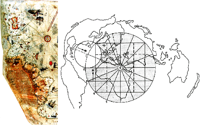 Combination of Piri Reis’s map with the modern map Several optimist sea travelers believed existence of “Southern land” in the middle of XVI century. One of them was well-known Spanish seaman, architect and annalist Pedro Sarmiento de Gamboa, who defended that idea even before publication of popular “Atlas” of Gerhard Mercator. The well-known Spanish sea traveler Alvaro de Mendana de Neyra organized expedition towards the south of the Pacific Ocean in accordance with his offer in order to find the mythical country Ophir located in the south of the Earth. All coordinates were restored in accordance with investigations carried out by American architects and cartographers Blanche, Mueller and Walter. It turns out that, coastlines of the Old World, New World and Antarc-tica were described on the map exactly. The coastline of Antarctica wasn’t covered in ice in 11-4 thousand BC. It means that, cartography had developed 6 thousand years ago as highly as the present time. Besides the eastern coast of South America, the western coast and Ant Mountains also were described on the map of Piri Reis. The well-known Flemish cartographer Abraham Ortelius described “Southern land” in the southern part of the Pacific and Indian Oceans on his map “Theatre of the world” consisted of 53 maps. This idea was supported by another well-known Flemish cartographer Gerhard Mercator, who described “Southern land” in his atlas. 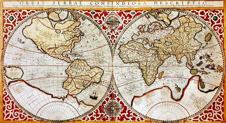 The world map of the middle ages. The author – Gerhard Mercator This fact caused all scientists to think. How could the Turkish admiral describe mentioned places exactly? There is no doubt that, mentioned map wasn’t made by Piri Reis only. Who was the real author of the map and when was it made? Ch. Hapgood came to the following conclusion when analyzed the map: “Exact information is exchanged between nations. The map was made by unknown nation and was found by Phoenicians and Creteans, who were considered genius seamen during more than thousand years, in ancient times. It became clear that, such maps were kept in the Great Library of Alexandria located in Egypt before being annihilated by the Crusaders in VII century”. The ancient Greek scientist Fukidid wrote: “The most famous tsar of Creteans Minos had established navy and occupied large part of the Ellyn Sea and Kirkland Islands”. As if they were in a hurry. Other nations living around the Mediterranean Sea couldn’t use navigation, vessels and maps as professionally as they did. Almost everybody knew that, Phoenicians were skilful seamen. They systematically sailed to the Atlantic Ocean from the Strait of Gibraltar and investigated coasts of Europe and Africa. Phoenicians used ancient maps for sailing in the ocean safely. Most researchers wrote that, Piri Reis’s map was used by other cartographers too. It means that, those maps were kept in Alexandria in several copies. They were spread all over the world after Egypt was occupied. Descriptions of Antarctica also were spread in several countries. I think, Gerhard Mercator, Oronteus Fineus and Philipp Buache also had such maps. 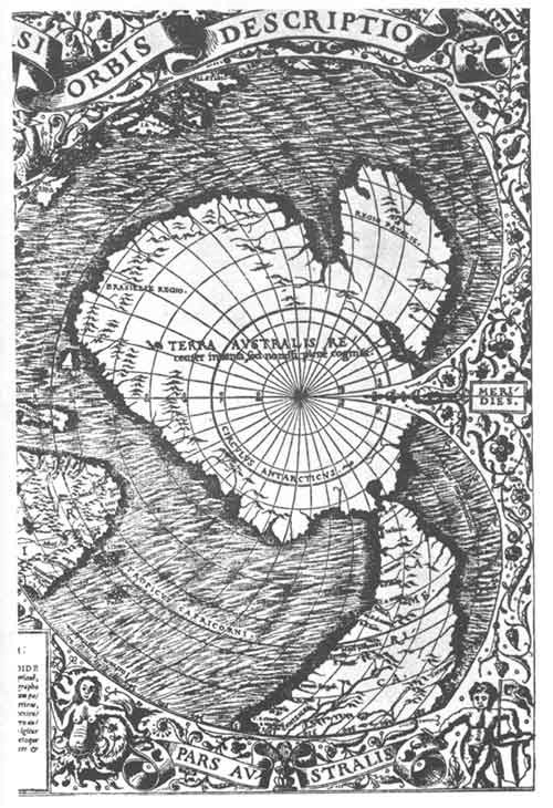 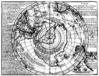 The Orontius Finaeus map of Antarctica The map made by Philippe Buache in 1739 made in 1532 Some scientists including Ch. Hapgood wrote that, sensational maps made by above mentioned experts were kept in the Library of Alexandria and were taken to the library of the Byzantine Empire afterwards together with other documents. Probably, most copies of mentioned maps were taken to Venetia in 1204 owing to Venetian seamen. But nobody can surely mention that, that material was given to the Turkish admiral by Venetian seamen or merchants. It couldn’t happen as there was a war between Ottoman Empire and Venetia. All these facts prove that, cartography is one of the most ancient science branches and there were professional cartographers – authors of exact maps even 15000 years ago. Afterwards mentioned maps began to be spread in new civilization centers of the world. email: [email protected],
 29713 29713 |
|


 |
 |