
 AZ
AZ EN
EN RU
RU
THE SENSATIONAL MAP FOUND IN THE TOPKAPI PALACE MUSEUM OF ISTANBUL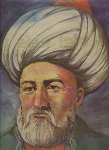
The admiral Piri ibn Haji Mammad Reis (1475-1554) was an experienced captain, talented navigator, skilful navy captain, well-known navy commander, professional navigator officer and educated cartographer of his time. His maps were the most necessary aids for the science of navigation.
Doktor Edhem found an ancient map drawn on the pergament made of the gazelle skin when they carried out restoration works in the Topkapi Palace Museum of Istanbul in 1929. That map was made in Chelibolu in the month of Muharram of 919th year of the Islamic calendar (1513). Piri Reis made an atlas in 1528 and included this map in that atlas by fixing the date as 1513. The Admiral`s map has two parts: one of them was made in 1513, another one in 1528. Afterwards it turned out that, mentioned historical material was copied from ancient manuscripts kept in the library of Constantinople. Libraries of Pergamum, Babylonia, Alexandria, Baghdad, Tabriz, Maragha, Damascus and Athens were moved to Istanbul during wars. Everybody knew that, there were a lot of ancient manuscripts, maps, anthropological and ethnographical information in mentioned library and it was possible to get sensational information by getting acquainted with them. Piri Reis’s map, where outlines of the Western Hemisphere were described, was one of such materials. It was almost the first map, which described outlines of America. Besides it, the sensational material included outlines of North America and Antarctica. It was made 21 years after the first travel of Columbus. But the Genoese admiral hadn’t visited the continent besides eastern coasts of Panama, Nicaragua and Honduras. Antarctica was discovered after more than 300 years by Fadday Bellingshausen and Mikhail Lazarev (1819). Piri Reis had copied lines from other ancient maps and included notes of Columbus made during his travel in his map. The Turkish admiral admitted that, he had copied western part from Columbus’s map. It means that, the well-known traveler had unique maps, which stimulated his first travel. It should be taken into consideration that, historians and geographers carried out unsuccessful researches during hundreds of years in accordance with “Columbus’s lost map” made by Columbus in West End islands. Though necessary devices and equipments didn’t exist then, coordinates of South America and Africa had been determined exactly. Could such map be made by any well-known cartographer, geographer or sea traveler of Europe? The American secretary of state Henry Stimson also was interested in this investigation. He thought that, “Columbus’s map” could be in Turkey. He ordered the ambassador of USA in Turkey to start researches in order to find mentioned map. Though the Turkish government supported researches comprehensively, any success couldn’t be achieved. Piri Reis mentioned that, he had used about twenty maps made during the age of Macedonian Isgandar in accordance with exact calculations. Scientists couldn’t believe the Turkish admiral’s statements as aerocosmic technology didn’t exist then. There wasn’t any copy of maps made during the age of Macedonian Isgandar. The Turkish admiral’s map caused great resonance in Turkey. 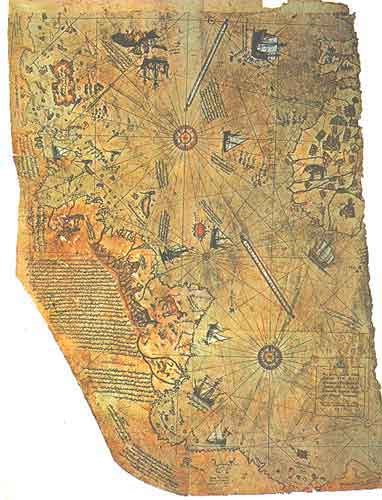 Piri Reis’s map (1513) Experts of the USA and especially captain Arlington X. Mueller, who was considered professional expert in the fields of cartography and navigation analyzed mentioned map in 50s years of XX century and get sensational result. The coastline of the Queen Maud Land covered in ice had been described in the southern part of the map. Probably, the map was made when mentioned territory wasn’t covered in ice. Of course, this sensational result amazed experts. As opponents of Mueller didn’t accept his result, he resorted to help of the director of Weston observatory attached to Boston College Daniel L. Lainhen and director of the observatory attached to Georgetown University Francis Hayden for verification of his result. Mentioned experts participated in the radio discussion made on August 26, 1956 on this theme. The theme was spread all over the world. After it, the Professor of Kinsk College located in New Hampshire Charles H. Hapgood began to be interested in mentioned theme. The map was included in the program of scientific investigations of Kin-State College owing to his efforts.  28879 28879 |
|


 |
 |