 AZ
AZ EN
EN RU
RU
PORTUGAL`S ALTERNATIVE WAY TO SHORES OF BRAZIL - III PART(the begining of article: “Bulls of Popes or division of the world”)Cral Juan II starts preparing the secret expedition without notice Spaniards. B. Dias knew western coasts of Africa located between north and south, but Pereira knew islands and archipelagos located in the Atlantic Ocean, which were known for Portuguese seamen. As he knew places of archipelagos and currents very well, he had to be entrusted with the discovery of Brazil. In a word, the Portugal kingdom could appropriate very large territory owing to Duarte Pereira. Nevertheless, if that expedition resulted in failure as previous travels, they had to be satisfied with islands discovered in the Atlantic Ocean. The expedition had to be started in 1493. As hot days had passed and stormy weathers were characteristic for autumn of those latitudes, this work had to be carried out on the north-western coast of Africa. That’s why Pereira thought that, he had discovered an island besides a continent as he hadn’t time to check the coast line. Columbus also declared that, he had discovered a group of islands after his first travel. In spite of all these, Pereira returned to Lisbon in the first quarter of 1494. Every detail of the prepared report was checked seriously. Special attention was paid to coordinates of the discovered territory. I looked through some versions of coordinates and came to the following conclusion: Pereira had reached Brazilian coasts at 10 south latitude and 420-430 west longitude in the territory of San-Luis and Belen. As the coast line is cracked in that territory and the territory of San-Luis is situated on the peninsula, the seaman thought that, he had met with a group of islands. You may ask why I emphasize that, Pereira reached the territory of today’s San-Luis. I think that, Pereira sailed towards the west by means of the South Passat current near Guinean coasts and met with Guiana and Brazilian currents in the threshold of South America. As the Guinea current moving towards the north rose to latitudes of the Pyrenean peninsula, Pereira chose that current and sailed to 10 south latitude. It was easier to return to Europe from that latitude without wasting time. The expedition organized in accordance with the order of the king Manuel I after six years, sailed from Green Cape Islands towards the south under the leadership of Cabral. They sailed towards the west by means of the South Passat current and approached the coast line by means of the Brazilian current blowing towards the south. The king Juan II, who was satisfied with results of Pereira’s expedition, asked his diplomatists to organize new negotiations. They had already prepared answers of questions, which would be given by Spaniards’ representatives and pontificator. 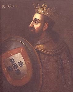 King of Portugal Juan II (1455-1495)
Portuguese, who had enough necessary information, demanded to move the demarcation line towards 500 west longitude in order to ensure fair division as if they didn’t know anything about existence of Brazil.
Why did representatives of Spaniards agree with demands of their rivals without any resistance? Representatives of Portuguese benefited by results of the discovery made during Cabral’s first travel as islands discovered by the Genoese admiral were situated at 650-700 west longitude and the territory discovered by Pereira was situated at 420-430 west longitude. As 250-300-buffer zone appeared between made discoveries, Portuguese were sure that, Spaniards wouldn’t object to moving the demarcation line for 45-470 towards the west longitude. It should be especially mentioned that, Portuguese were successful in that business too. Bahamas, islands of Haiti and Cuba were first lands discovered by Columbus during the transatlantic passage and there weren’t any land in the east of them. Thus, if there was any territory in the east of known islands, Portuguese had an opportunity to appropriate it. Admiral’s report described only ocean waters in the east of the 65th and 70th meridians. Portuguese, who used Spaniards’ mistake, sent secret expedition to South American coasts hurriedly, discovered large land area in the east of the considered meridian and kept it secret. Juan II had to invite Spaniards to negotiations and to register secretly discovered lands officially. Though negotiations hadn’t any significance for some time, they were restored afterwards and the treaty of Tordesillas was concluded on June 7, 1494. As it is known, the demarcation line was moved for 370 liq – 460 30/ towards the west from Azores and Brazil became property of Portugal. America became property of Spanish kings besides the remote western part of today’s Brazil. Thus, political geography of coasts of the New World was founded and the Pope sealed it up. 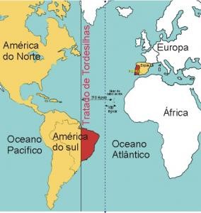 The demarcation line according to Tordesillas treaty Thus, Portuguese swindled Spaniards by means of the Pope Alexander Borgia VI and appropriated Brazil which’s total area was equal to 8,5 milion square kilometers. That unjust division disclaimed efforts of Spaniards as Brazilian coasts were visited by Spanish sea travelers Vicente Pinson and Diego Lepe for the first time. Portuguese should be grateful to Duarte Pereira, but not Pedro Cabral for being owner of Latin America. Most seamen weren’t successful in discovering lands in the west of the Atlantic Ocean though following task was given to them. But Pereira could achieve mentioned goal. The experienced captain discovered lands, which were very important for the king Juan II, and could return to Europe before next negotiations held with Spaniards. Besides it, he participated in negotiations held in Tordesillas and swindled Spaniards by means of the Pope. The captain was obliged to keep this secret till the day he died. Spanish monarchs began to send different expeditions to coasts of South America and especially Brazil after the treaty of Tordesillas was concluded. Vicente Pinson went ashore and started exploration works at 80 south latitude, Diego Lepe at 100, 50 30/ south latitude, Bartolome Roldan at 50 30/ south latitude, Alonso de Mendoza at 70 south latitude. Vicente Pinson, Diego Lepe, Pedro Alonso Nino and Alonso Okheda explored Brazilian coasts on the north-west after they went ashore, but Alonso de Mendoza did it on the south-west. Even Pedro Alonso Nino explored those territories on the west of the demarcation line. Best regards, the member of Azerbaijan Geographic Society, President grant holder on literature, laureate of the “Golden pen” award, writer/ investigator Ramiz Daniz  27444 27444 |
|


 |
 |