 AZ
AZ EN
EN RU
RU
SOME ISLANDS ON THE ATLANTIC OCEAN WERE KNOWN BY MUSLIM SCIENTISTS - PART IChristopher Columbus presented his transatlantic project to the king Juan II at the beginning of 1484 when lived in Portugal. But that time wasn’t convenient for the monarch of Portugal. Then the king was busy with suppressing revolt raised in the country by magnates. Besides it, he was interested in expeditions towards western coasts of Africa.
It is known that, Columbus had asked the king to give him many privileges for his services after the expedition completed successfully. To ask such privileges was insolence. Nobody, even well-known noblemen hadn’t asked such privileges before Christopher Columbus. What were demands of the Genoese seaman? He had demanded to be admiral of the Atlantic Ocean, title of nobleman, to be vise-king of lands, which had to be discovered, one tenth of incomes of those lands, eight percent of money, which would be earned at the result of the trade, which would be carried out in new lands and gold spurs. Juan II, who kept his noblemen under the strict surveillance, couldn’t give mentioned privileges to anybody. If Juan II was very strict and harsh monarch, why he didn’t reject Christopher Columbus directly? First of all, seaman’s project had to be analyzed by scientists. The project was presented to “Mathematical Union” of Lisbon where the most talented and skilful scientists and mathematicians of Portugal worked under the leadership of the archbishop of Сeuta Diego Ortiz de Villegas. Some of members of that organization were Jewish scientists. Rodrigo, who had improved astrolabe and sextant, and expert of the navigation astronomy Hose Vitsingo were among those scientists. Mentioned persons thought that, measures and distances hadn’t been fixed correctly in the project. Though those scientists also didn’t know exact sizes of the Earth, they were sure that, calculations of Columbus were wrong. 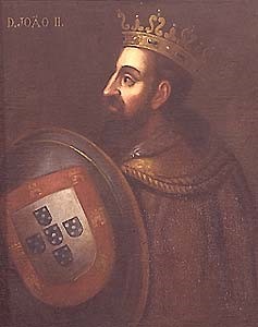 King of Portugal II Juan (1455-1495) It is not known which decision was made by that council, but it is known that, decision made in 1485 wasn’t in favour of Columbus. The Genoese seaman’s wife died in the same year and he decided to go to Spain. As soon as the Genoese seaman left Lisbon, the king Juan II decided to send an expedition to the west of the Atlantic Ocean in order to check his project. The king and his advisers made this decision by common consent. At that time the “Island of Seven Cities”, Haldat and Anthelia Islands located in the west of the Atlantic Ocean were discussed in the Pyrenean peninsula and most countries of Europe. Portuguese sea travelers had organized several expeditions for the discovery of those islands. Scientists of the middle ages and ancient times were interested in Haldat islands or Islands of Good Luck very much. Some scientists, especially remarkable Azerbaijani scientist, founder of Maraga observatory Muhammad Nasiraddin Tusi (1201-1274) noted that, those islands were situated at 350 km towards the west from Greenwich meridian. English scientist G. R. Kaye, who was interested in this problem very much, noted in his work “Astronomy of India” that, Islands of Good Luck were situated at 350 towards the west from Greenwich meridian.1 Why did G. R. Kaye think so? Most of scientists of the middle ages and ancient times thought that, Islands of Good Luck were in the west of the Atlantic Ocean. Remarkable scientist of the Mamun Academy established in Khorezm Abu Raihan Al-Biruni (973-1048) wrote about it as following: “Some scientists calculate the initial length from Islands of Good Luck, but some of them start calculation from the coast of the West Sea. Difference between these two places is 100”. 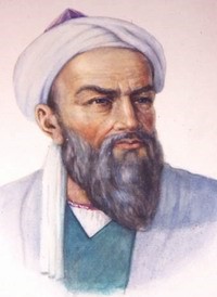 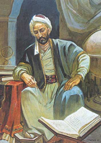 Abu Raihan Al-Biruni (973-1048) Muhammad Nasiraddin Tusi (1201-1274)
Arabian geographer of Spain Ali ibn al Magribi al Andaluzi, Syrian scientist, employee of Maraga observatory Gregory Abul Faraj, remarkable scientist of that observatory Gutbaddin Shirazi, well-known geographer and historian of XIII century Mahmud el-Caswini and well-known Arabian scientist of XIV century Harrary had different scientific ideas about those islands. Harrary’s explanation is more interesting: “Western lands start from the West Sea. Nobody had seen another side of this sea and nobody knows what there are. Most of islands have been settled. Two of them are called Algeria Haldat. They are the largest islands”. This thought of the Arabian scientist surprised the Professor Habibulla Mammadbayli, who had investigated scientific heritage of Nasiraddin Tusi, and he wrote following thoughts: “Harrary’s notes are very interesting, he had written about western lands and Anthelia Islands. The Atlantic Ocean was called West Sea in the middle ages. Islands mentioned by Harrary might be Canary Islands, Azores, Green Cape Islands or Anthelia Islands. As Canary Islands, Azores and Green Cape Islands don’t consist of many islands and there aren’t great differences between them, they couldn’t be considered by Hararry. It seems that, Harrary mentioned Anthelia Islands in his writing. Two of Anthelia islands – Cuba and Haiti are larger than others… Then these two islands are Algeria Haldat, which was mentioned by Harrary…”1 If Harrary had written about Anthelia Islands at the beginning of XIV century, there had to be some information about those islands in geographical literature, especially on maps published after it. Ancient scientists noted that Anthelia Islands were situated in the east of Asia. Really, maps describing mentioned islands had spread widely in Europe. Italian cartographer Francesco Pizziano had made a map describing Anthelia Islands in 1367. That map is kept in the library of Parma at present. Besides it, another map made by the unknown cartographer in 1424 is kept in Weimar, Germany. That map had been made by the German scientist Humboldt. The French cartographer Battista Beccaria had made a map in 1435. Besides the name of Anthelia, its synonym Stanahia also had been written on that map. In 1436, the Italian cartographer Andrea Bianchini had made the Big Venetian map, which described Anthelia Islands. The Italian scientist Paolo Toscanelli described Anthelia on the centre of the Atlantic Ocean on his map made in 1474. 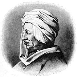 Paolo dal Pozzo Toscanelli (1397-1482) Most of mentioned maps were discussed by European scientists. Scientists knew that, coasts of the Atlantic Ocean located in the west of the Old World weren’t endless and there wasn’t any doubt that, there was large land area in the west. But distance between that territory and European coasts was unknown. (Continue of article: “Ferdinand van Olmen and the transatlantic project of Columbus”) Best regards, the member of Azerbaijan Geographic Society, President grant holder on literature, laureate of the “Golden pen” award, writer/ investigator Ramiz Daniz email: [email protected], [email protected] 1 Г.Р. Кае «Индийская астрономия» 1924, стр. 52
1 H.C.Məmmədbəyli, Mühəmməd Nəsirəddin Tusi. Bakı, “Gənclik”, 1980. səh.160-161.
 26136 26136 |
|


 |
 |