 AZ
AZ EN
EN RU
RU
MARTIN WALDSEMULLER AND THE GEOGRAPHY CIRCLE OF SEN-DYEAmerigo Vespucci had to attract attention of some foreign scientists in order make “his travels” official. He couldn’t reach top of the fame though he had great support in Spain. Major geographical discoveries were made successively. He had to spread information about discovered lands and aborigines, who lived there. The winner would be the person, who could do it.
The transatlantic travels had to be kept secret as they served state’s interests. Everybody, who would spread such information, had to be judged as a traitor. But Vespucci didn’t fear and spread information on the lands discovered on the other side of the ocean. It means that, he showed irresponsibility by doing it. But he wasn’t punished for spreading state secret, vice verse, was appointed head navigator of Castile by monarchs of Spain. 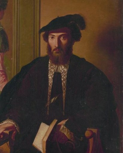 Amerigo Vespucci (1454-1512) A geography circle was established in the city Sen-Dye of Lotharingia in France in 1507. Several young scientists were members of the circle. One of them, Martin Waldsemuller published “Introduction to cosmography” with two letters of Amerigo Vespucci (in Latin). The name “America” was used in that book for the first time. The author wrote that, three parts of the Earth were named Europe, Asia and Africa. Martin Waldsemuller wrote: “Now… The forth part was discovered by Amerigo Vespucci and I don’t think that anybody will be against naming it America”.1 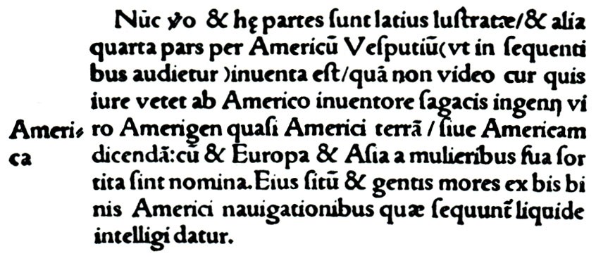 Lines from the book written in 1507 by Waldsemuller. It is suggested to name new continent America in favor of Vespucci – wise person 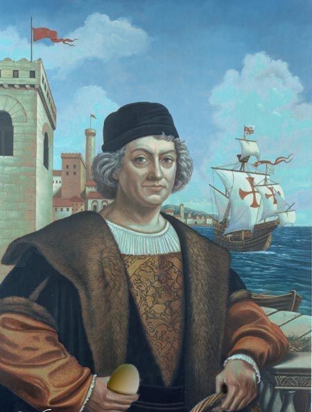 Christopher Columbus (1451-1506) According to mentioned authors, the German cartographer and geographer Martin Waldsemuller (1470-1521) didn’t want to cast a shadow on the reputation of Christopher Columbus though Amerigo Vespucci, Alonso de Ojeda, Vicente Pinzón, Diego Lepe and other sea travelers weren’t known as travelers, who organized expeditions to the new lands, by some geographers. But some of them began to appreciate the Florentine cosmographer as Columbus after letters of Vespucci, which were spread in most countries of Europe. According to them, Christopher Columbus investigated the Old World – tropical part of the Eastern Asia, but Amerigo Vespucci investigated the new continent – “the forth part of the Earth” – New World. But in spite of it, there was a striking difference between them. Because, Christopher Columbus could reach the Atlantic Ocean in the west first of all. Wise and idealist scientists knew it very well. 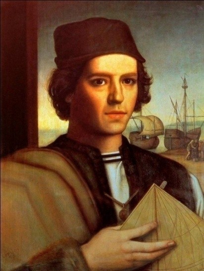   Vicente Pinzón (1460-1523) Diego Lepe (1460-1515) Alonso de Ojeda (1468-1515) Members of the geography circle of Sen-Dye accepted Amerigo Vespucci’s letters as information about discovery of the new continent. If the new continent was discovered, it had to be named. If Martin Waldsemuller didn’t make mentioned speech in Sen-Dye because he was prompted to do so, he had to name the new continent, discovered by Columbus in 1492, Colombia instead of America. But the scientist chose unexpected name for it. The purpose of Waldsemuller’s scientific work was to name America. He had added his map to his work. Which sources were used by Martin Waldsemuller when he prepared that map? Were there such maps in Lotharingia or territories around? There may be maps in Lotharingia and other territories, but the map “made” by Waldsemuller couldn’t be found in France, Holland or England. 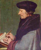 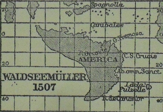 Martin Valdzemüller (1470-1521) The map made in 1507 by Waldsemuller It is known that, most maps of territories, located in several parts of the Earth, could be found in large trade ports, located on the coasts of the Mediterranean Sea, including centers of culture and religion of cities, where important scientists, humanists and theologians lived. But number of maps of coasts of the New World, was limited and they were kept in important administrative buildings under special control. It was almost impossible to spread those maps. Then, how could Martin Waldsemuller get that map? It was great responsibility for all researchers to introduce it as an author. As I mentioned above, number of maps of coasts of the New World was limited. But that map included exact latitudes and longitudes. The word “America” was on such an exact map. There is no doubt that, such map couldn’t be made by Martin Waldsemuller. Martin Waldsemuller and his colleague Matthias Ringmann, who worked in Sen-Dye-de-Voj, worked on small maps. Maps had 12 segments and they were printed on one paper. A globe with 12 sm diameter appeared when papers were approached to each other. 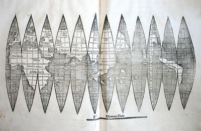 The map made by Martin Waldsemuller and
Matias Ringman, which was consisted of 12 segmentsOnly 4 copies of maps, consisting of segments, were known. Three of them were in Minneapolis, Offenburg and Bavaria State Library of Munich. The forth was sold for 1 million dollars by auction “Christis” in 2005. The original map, remained till the present day, was consisted of 12 parts (planks). Map’s original title was “Universalis Cosmographia Secundum Ptholomaei Traditionem et Americi Vespucii Alioru[m]que Lustrationes”. Its translation is “Map of the world made on the new lands added by Amerigo Vespucci with the method of Ptolemy”. As existence of today’s Northern America wasn’t proved at the beginning of the 16th century, Martin Waldsemuller was obliged to write “America” on the South America. If Amerigo Vespucci really sailed to the coasts of Florida as some historians wrote, this name could be written on the Northern America too. But as Spanish and Portuguese sea travelers investigated only northern and eastern coasts of the South America and never were in the territories, located on the northern coasts of the Caribbean Sea, it was difficult to name that territory. The Florentine accountant sent his letters to the most influential person of the Apennine Peninsula. He was a statesman of the Republik of Florense Piero di Soderini. Piero di Soderini sent the letter to the duke of Lotharingia Rene II after he get it. Best regards, the member of Azerbaijan Geographic Society, President grant holder on literature, laureate of the “Golden pen” award, writer/ investigator Ramiz Daniz 1 И. П. Магидович, В. И. Магидович. Очерки по истории географических открытий, II том. Москва, “Просвещение”, 1982. стр. 79
 21397 21397 |
|


 |
 |