 AZ
AZ EN
EN RU
RU
FIRST, SPANIARDS HAVE DISCOVERED BRAZIL - PART II (the begining of article: “Vicente Janez Pinson, Diego Lepe or who officially discovered Brazil for the first time?”)
Spaniards had other purposes in sending those expeditions to Brazilian coasts. They wanted to know exactly if there was land area on the demarcation line officially determined by Portuguese. After secret expeditions were sent to that territory, it became clear that, there were enough lands there and Spaniards understood that Portuguese had swindled them. But as the scale of deception wasn’t definite, Spaniards couldn’t protest against it. It needed to explore mentioned territory and so secret and permitted expeditions began to be sent there. They were interested in one thing only: area of the land got by Portuguese in accordance with Tordesillas treaty and the latitude where it located. The border was definite owing to the meridian division and Spaniards wanted to know where that border extended to. Pedro Alonso Nino explored those territories on the west of the demarcation line. Vicente Pinson went ashore and started exploration works at 80 south latitude, Diego Lepe at 100 30/ south latitude, Bartolome Roldan at 50 30/ south latitude, Alonso de Mendoza at 70 south latitude. Vicente Pinson, Diego Lepe, Pedro Alonso Nino and Alonso Okheda explored Brazilian coasts on the north-west after they went ashore, but Alonso de Mendoza did it on the south-west. Amerigo Vespucci, who had participated in the expedition of Vicente Pinson, approached Brazilian coasts at 50-60 south latitude and sailed towards the south. He had to determine where southern coasts of Brazil extended to. But he couldn’t fulfill his mission too. As if, all travelers had to prevent Spaniards’ indifference in those territories in accordance with the special task. Spanish monarchs wanted to know which part of lands located on the other side of the Atlantic Ocean became Portuguese’s property after Tordesillas treaty. After the distance between parallels was calculated, it became clear that, they owned very large territory. It means that, Portuguese sea travelers owned very large territory without any trouble. May be, Portuguese, who pretended as simpleton when Tordesillas treaty was concluded, swindled Spaniards? They could increase the demarcation line for 270 liq during the second division and take the territory as large as today’s Brazil from Spaniards. 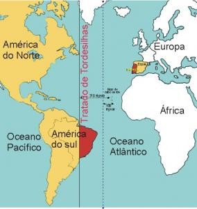 The demarcation line according to Tordesillas treaty Brazil belonged to Portuguese in accordance with Tordesillas treaty, but it had to be registered officially. After the discovery was registered, expeditions would be sent for exploration of that territory. Several candidates were presented to the king for realization of this work, but he chose Gonzalo Coelho. It is very interesting that, though that expedition was very important, name of its leader was kept secret for several centuries. The great adventurer Amerigo Vespucci showed this travel as his own achievement. As if, he was the leader of that expedition in 1501-1502. But justice is restored sooner or later. Gonzalo Coelho, who had left coasts of Portugal in 1501, was known as the assistant of Amerigo Vespucci for a long time. It had been mentioned in several sources that, Vespucci had explored northern coasts of South America within the expedition of Alonso Okheda. He visited coasts of this continent during the expedition of Gonzalo Coelho for the first time. Amerigo Vespucci was non-official navigator within the expedition of Coelho sailing to Brazilian Coasts and he had to write everything happened during the exploration. His notes are still remaining together with several maps of “Santa Cruz” or “Land of parrots” – coast line of Brazil together with rivers and bays made in XVI century. Thus, captain-general Gonzalo Coelho left Lisbon with three vessels on May 10, 1501 and met with the expedition of Cabral returning from Green Cape Islands on June 1. His mission also was considered partly secret. But in spite of it, he had got some information about Pedro Cabral’s travel to Brazilian coasts and understood that, travelling to the west of the Atlantic Ocean was easier than travelling to India and south of Africa. They met with Fernando de Noronha Island surrounded by rocky places after five-week ocean passage as soon as found fresh water in Bijagos archipelago during 11 days and reached the coast of the continent on August 17. Portuguese stayed in the first cape for a week and then continued their way. Two seamen went ashore in order to establish commercial relations with indigenous population, but didn’t return back. Though Amerigo Vespucci offered to punish Hindus, Gonzalo Coelho sailed towards the south without any conflict. As exploration of the coast line was especially significant, every point was noted exactly. Every point was called by names of holy persons. Those names show which point they visited first of all in the north. Some scientists write that, a number of seamen used to make efforts in order to discover Brazil. A man by name John Jay organized an expedition on his own account in order to discover the Brazil Island in 1480. He thought that, it was situated in the west of Ireland. After six-week travel, the expedition returned back without achieving any results. 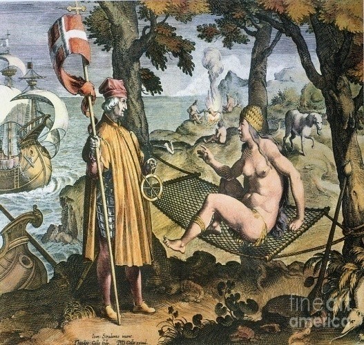 Amerigo Vespucci’s first meeting with Hindus in the New World Seamen reached Angra dos Reis bay on January 6, San-Vicente Island (240 south latitude) after 16 days and outfall of Cananea River at the end of January (250 south latitude and 480 west latitude). There Gonzalo Coelho completed his works and decided to return to the motherland. One of vessels of Ferdinand de Noronha left the marine and came to Lisbon on June 24, 1502. We met with the fantasy of Amerigo Vespucci when chronology of this expedition is analyzed. According to his information, remained two vessels left Brazilian coasts on February 13, continued the expedition towards the south, overcame 3000 km and met with new land at 520 south latitude on April 3. I. P. Magidovich and V.I. Magidovich suppose that this land was Trindade Island located at 200 south latitude and 300 west longitude. There seamen asked the captain-general to return back and they reached coasts of Sierra-Leone on May 10. There Gonzalo Coelho burned one unfit vessel, continued his way and dropped anchor in Lisbon on September 6, 1502. 1 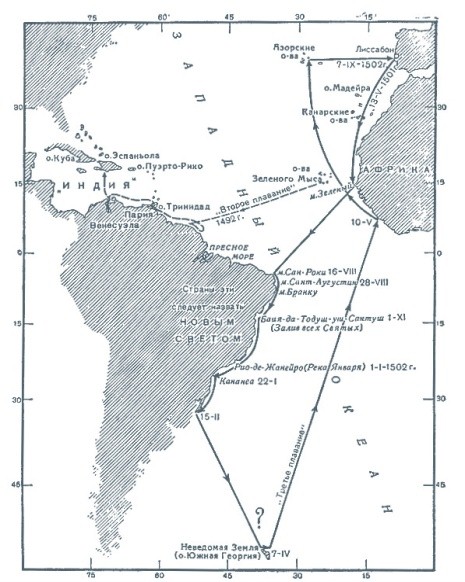 Amerigo Vespucci’s unreal discovery Though the expedition couldn’t find any gold and silver, it could achieve great geographical successes. It explored 3000 km coast line between San Roka Cape and Cananea River from 50 30/ south latitude to 250 south latitude, 1000 km from 50 30/ south latitude to 160 south latitude and included them in the new map. Achievements of that expedition kept as secret for 450 years and Amerigo Vespucci had significant role in it. He hadn’t mentioned name of Coelho when wrote about the expedition and misappropriated all achievements of the mission. Only at the end of 60th years of XX century, an old map of 1504-1505 was found in the library working in Fano, Italy. Brazil was called “Land of Gonzalo Coelho” in that map. After it, it became clear that, Gonzalo Coelho had played significant role in exploration of Brazil. It is necessary to analyze geographical points where Coelho approached in order to determine real purposes of Portuguese, to learn if Pedro Cabral reached Brazil by accident and if any traveler visited that continent before Cabral. The expedition approached San Roka Cape at 50 30/ south latitude in the north on August 17. That cape had been discovered by Pinson and Lepe a year before. Portuguese had to work there in order to disconsider exploration works carried out by Spaniards in that territory as the territory might be lost later. Portuguese had to prove that vessels of Pinson and Lepe approached Brazilian coasts in the east of the demarcation line and results of their activities had to be disconsidered. Portuguese had to end Spaniards’ activity in accordance with juridical documents. Several sources prove that, Gonzalo Coelho didn’t know at which latitude Pedro Cabral approached Brazilian coasts. But it doesn’t seem convincing as Cabral sent Gaspar de Lemos to Lisbon on May 1 in order to inform the king about the “discovery” after Brazilian coasts were seen. So we may note that, Gaspar de Lemos met Coelho in Lisbon and got information about Brazil. Thus, Coelho knew that, Cabral had approached the coast at 160 30/ south latitude (today’s Porto Seguro).  Pedro Alvaresh Cabral (1467-1520) Gonzalo Coelho, who could disconsider Spaniards’ achievements sailed towards the south and reached Saint Augustine (Kabu Branku) Cape on August 28. He met with well-mannered Hindus in the south and three Hindu women agreed to go to Portugal together with comers. Seamen stayed there for a month and then passed outfalls of small rivers flowing from Borborema mountains – San Miguel (September 29), San Geronimo (September 30) and San Francisco located at 100 30/ south latitude (October 4). The expedition approached Todos Santos bay located at 130 south latitude on November 1. It was the coast of the largest bay of the territory and later it began to be called “Bahia” (Bay). In Porto Seguro the expedition took two sea boys left by Cabral a year and a half before. It proves that Hindus were peace-loving people. Portuguese, who continued their way, left the outfall of Santa Lucia (Dosi River) behind on December 13, passed San Tome Cape (220 south latitude) on December 21, again sailed towards the west and reached amazing Guanabara Bay on January 1. They thought that it was the outfall of the river (230 south latitude) and called it Rio de Janeiro – “January River”. Though members of the expedition sailed to Brazilian coasts in order to explore those places in accordance with the official statement, they had more important task in reality. According to that task, Gonzalo Coelho had to determine at what distance of the eastern or western part of the demarcation line fixed in accordance with Tordesillas treaty the territory “discovered” by Cabral was situated. As if, previous expedition hadn’t been able to determine coordinates of the coast. Portuguese did it in order to disguise the lie described in Tordesillas. Thus, three caravels of Gonzalo Coelho went down for 500 km from the point they had approached in the coast and reached the outfall of large river on the first day of 1502 (territory of today’s Rio de Janeiro). Amerigo Vespucci sailed to those coasts during the second expedition (1503-1504) together with Gonzalo Coelho, described most events happened during that travel in his writings and published them in Europe for several times. I want to note that, the mentioned travel could end with tragedy. But Portuguese ignored everybody, who had discovered Brazil, especially Pinson and Lepe and noted that the Portuguese seaman Duarte Pacheco Pereira and German scientist Martin Behaim working for Portugal had visited those territories in 1490-1495, but it was kept secret in order to prevent visit of other people. Though arguments were enough, it hadn’t been proved yet. Martin Behaim (1459-1507) Best regards, the member of Azerbaijan Geographic Society, President grant holder on literature, laureate of the “Golden pen” award, writer/ investigator Ramiz Daniz 1 И. П. Магидович, В. И. Магидович. Очерки по истории географических открытий, II том. Москва, “Просвещение”. 1982. стр.59
 26552 26552 |
|


 |
 |