 AZ
AZ EN
EN RU
RU
PORTUGUESE TRAVELERS CARRYING OUT RESEARCH IN THE ATLANTIC OCEAN - PART II(the begining of article: “Good offices of Martin Behaim and explanation of questions concerning Brazil”) Portuguese discovered all islands near north-western coasts of Africa and Pyrenean peninsula during 45 years and included them on the territory of the Portugal kingdom. Vessels of two Portuguese noblemen, who had sailed to the Cape Bohador in 1419 – Juan Gonsalvich Zarku and Tristan Vash Tashera moved away from the west at the result of the storm, met with the island covered with dense wood and created basis for the discovery of Madeira Island. The expedition sent from Portugal towards the west under the leadership of Gonzalo Velu Cabral according to the task given by the son of the king of Portugal Juan I – Prince Enrique (1394-1460) discovered Azores in 1427-1432. Alvise (Luici) Cadamosto from Venetia and Antonio Usodimare from Genoa discovered Cabo Verde (Green Cape) islands in 1456.  Prince Enrique (1394-1460) In general, Portuguese sea travelers – Jal Ionsh (1435), Afonso Gonsalves Baldaia (1436), Anthony Gonsalves, Nunu Tristan (1441), Lanzarote Pisania (1444-1445), Dinesh Dias (1445), Alvaro Fernandez (1446), Arish Tinoku (1447), Diego Gomes (1456), Alvise Cadamosto, Antonio Usodimare (1456), Antonio Noli from Genoa (1460), Diego Afonso (1462), Pedro de Sintra (1461-1462), Fernan Gomez (1469), Sueiru da Costa (1470), Juan de Santaren, Pedro de Iskular (1471), Rui Siqueira (1472), Fernando Po (1472), Diego Azanbuj (1481), Diego Can (1482-1484 and 1485-1487) and Bartolommeo Dias (1487-1488) began to discover all western coast of Africa and to prepare for future sea travels. Thus, Portuguese settled in Madeira in 1425, in Azores in 1432, and occupied Green Cape Islands in 1460. Diego Gomez came to Lisbon from Gambia in 1456 and brought 180 pound gold sand. That gold had been given him by indigenous population in exchange for simple glass decorations. Though this news spread in Castilia in the shortest time, he couldn’t carry out his activity in the Atlantic Ocean because of the Reconquista. Portugal used this opportunity and increased influence in the Atlantic Ocean. Expeditions of Portuguese sea travelers Jal Ionsh, Afonso Gonsalves Baldaia, Anthony Gonsalves, Nunu Tristan, Lanzarote Pisania, Dinesh Dias, Alvaro Fernandez, and Arish Tinoku had explored only north-western coasts of Africa and didn’t move away from the coast of the continent before 1448. There was great need for scientific theories of scientists, navigators, geographers, cartographers, astronomers and mathematicians in the discovery of unknown lands in the ocean. That’s why every work of scientists was interesting for sea travelers and organizers of travels. Well-known scientist of Florence lived in XV century and worked in fields of astronomy, medicine, geography and mathematics Paolo dal Pozzo Toscanelli (1397-1482) had great authority in kingdoms of Apennine peninsula and in whole Europe. 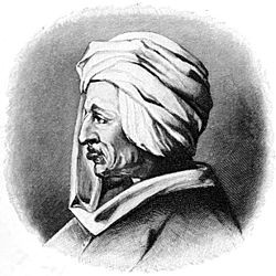 Paolo dal Pozzo Toscanelli (1397-1482) Translation of “Geography” written by Greek scientist Claudius Ptolemy lived in II century into Latin made him popular and famous world map made in 1474 brought him fame in Europe. Toscanelli told the king of Portugal Alfonse V that, the earth was round and it was possible to go to India through the west: “I’m sure that, if the earth is round, existence of this way may be affirmed. In spite of it, I send the map I had made in order to simplify your work. Route in the west, islands, coasts and the place you have to travel have been described on that map. The distance you have to keep from the equator and pole has also been fixed. Though it is known that, the place where spices finish and precious stones are found is east, I described that place in the west. You can reach that place if you go through land…” 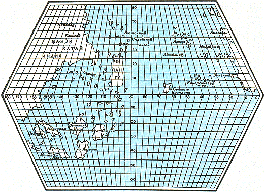 The world map made by Paolo Toscanelli in 1474 (reconstruction) The scientist, who didn’t afraid of wrath of the Catholic Church, defended his ideas in accordance with scientific theories and especially the work by name “Almagest” of Claudius Ptolemy (he noted in that work that the earth was spherical). Several scientists noted that, it was possible to meet with several continents on the western way to India. It is necessary to pay special attention to this problem. What did the king Alfonse V think about ideas of the scientist? It is known that, such serious projects and ideas were discussed in “Mathematical Union” consisting of scientists, mathematicians, astronomers, cosmographers and geographers and their importance was determined. The project of Christopher Columbus, which was presented to the king of Portugal Juan II after several years, was also discussed in “Mathematical Union” and the decision was negative. So he wasn’t provided with vessels for organization of an expedition towards the western part of the Atlantic Ocean. 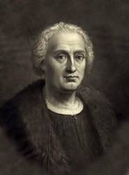 Christopher Columbus (1451-1506) After ten years – in 1484 Columbus presented another analogous project to the king of Portugal Juan II. The idea of the Genoese seaman thinking that it was possible to travel to India through the west was simple. The earth is round and the largest part of it is land – Europe, Africa and Asia. So the distance between the western coast of Europe and eastern coast of Asia is small: it is possible to reach India, Chine and Japan in the shortest time by passing the Atlantic Ocean through the west. Such thought corresponded to ideas of geographers of that time. Besides Paolo Toscanelli, Aristotle, Pliny the Elder, Strabo and Plutarch also thought that, such travel might be realized. The idea of Common Ocean was accepted by the church as well. Such theory was affirmed by the Islamic world including well-known Muslim geographers – Masudi, Al-Biruni and Idrisi. Portugal decided to sign contract with the kingdom of Spain in order to avoid conflict with the powerful neighbor. If the official contract signed with participation of the Pope didn’t exist, Spain could impede activity of expeditions of Portugal working in the Atlantic Ocean and pretend to discovered land. They signed contract with Madrid in Alcasovas in 1479. According to that contract, South America came under surveillance of Portuguese and Spaniards kept being hegemon in Canaries. According to the Pope’s bull “Aeterna Regis”, kings of Spain Ferdinand and Isabella refused all known and unknown lands located in the west of Canaries for Portugal on 21st of June, 1481. It means that, vessels of Spain couldn’t go down from the 28th parallel of the northern hemisphere. Best regards, the member of Azerbaijan Geographic Society, President grant holder on literature, laureate of the “Golden pen” award, writer/ investigator Ramiz Daniz email: [email protected], [email protected]  27824 27824 |
|


 |
 |