DUARTE PACHECO PEREIRA AND UNOFFICIAL DISCOVERY OF BRAZILSome historians note in accordance with the treaty concluded in Alcasovas that, Portuguese sea travelers had discovered lands located below the 28th parallel and in the western part of the Atlantic Ocean before 1479, but hadn’t registered it officially. It means that, those lands became property of Portugal in accordance with the bull of the Pope Sixtus IV. At the result of it, wars with Castilia were ended.
Though improvement of vessels simplified management at those days, navigation was realized in accordance with the direction of the wind and movement of currents. It means that, it is possible to reach today’s Brazilian coasts and to return back by means of winds and currents. Some scientists write that, a number of seamen used to make efforts in order to discover Brazil. A man by name John Jay organized an expedition on his own account in order to discover the Brazil Island in 1480. He thought that, it was situated in the west of Ireland. After six-week travel, the expedition returned back without achieving any results. Merchants of Bristol had been sending 2-4 vessels each year in order to discover the Brazil Island since 1490, but couldn’t achieve anything.1 As English seamen sailed in northern latitudes only, they couldn’t discover today’s Brazil. Besides it, they didn’t want to enter territories of Spaniards and Portuguese. According to historical sources, participant of Pedro Cabral’s expedition – Duarte Pereira had been in lands located on the other side of the Atlantic Ocean. It may be seen unconvincing. As Pedro Cabral had to register the “discovery of Brazil” when travelled to India, he needed a person knowing those coasts very well in order to prevent any unexpected events on their way. This person was Pereira. Well-known captain, explorer and cartographer Duarte Pacheco Pereira (1469-1533) had participated in expeditions in western coasts of Africa after II part of 80th years of XV century, met an accident near the Principle Island in 1488 and was rescued together with several seamen by the expedition of Bartolommeo Dias, who was returning from the Cape of Good Hope. He had participated in several secret expeditions, which’s route, geographical coordinates and coast lines were coded. 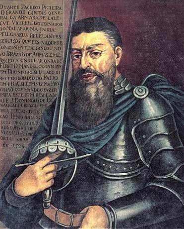 Duarte Pacheco Pereira (1469-1533) Duarte Pereira spent several years of his life for sailing in the eastern and middle part of the Atlantic Ocean and exploring unknown islands located in those areas. There wasn’t any thought about large territory yet. As only three continents were known at that time, ordinary seamen couldn’t think that, there might be fourth and fifth continents in the ocean. Thus, seamen of XV century didn’t know that, the Earth was larger than they know. But Pereira could reach Brazilian coasts in accordance with the secret task. The date of that history is unknown. Duarte Pereira noted in his work “Esmeraldo de Sita Orbis” (“Emerald about the position of the Earth”) written in 1505-1508 that, he had visited lands located on the other side of the Atlantic Ocean. As that work was a copy, scientists didn’t know what to think. Only three volumes and part of the fourth volume of the work consisting of five volumes (books) were found in Portugal libraries, those volumes were published and presented to the community in 1892 for the first time. The author gave information about existence of lands located on the other side of the Atlantic Ocean in the mentioned book and noted that he had visited those lands six years before Pedro Cabral’s expedition.1 Some scientists wanted to use this fact and to show Duarte Pereira as the discoverer of South America in 1494. The discovery of South America by Pereira was described in the large article of I volume of Pereira da Silva’s work “The history of the Portuguese colonization of Brazil”. J. Rocha Pombo noted that the Portuguese sea traveler had reached America before Cabral and Columbus. If we analyze Pereira’s activity, we can elucidate a number of questions. 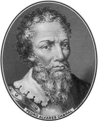 Pedro Alvaresh Cabral (1467-1520) Though original documents don’t exist, it is convincing that, Duarte Pereira had approached Brazilian coasts before Pedro Cabral. Concrete date is also mentioned as 1494. I also determined at the result of my investigations that, Pereira could reach Brazilian coasts first of all. Sometimes we need to use simple ways in order to solve complicated problems. What is this simple way? I will elucidate obscurities of the treaty of Alcasovas by investigating this question. It is known that, according to some scientists, Portuguese were aware of existence of Brazil before 1480 and that’s why could ask the Pope for opportune articles. First of all, I plan to look through bulls of Popes about division of the world. After it, I understood that Portuguese visited Brazilian coasts at the beginning of 1494. 1000 km trajectory of the Canary current is the most perspective way for passing the Atlantic Ocean from east to west in the northern hemisphere. That’s why though the ocean river flowing from north to south at 200 west longitude and through African coast line from 300 east latitude to 100 east latitude with the speed 10-30 sm/san was slow, it could assist vessels for approaching equator. An average depth of the Canary current is 500 meters. It is known that, Christopher Columbus used this current during his transatlantic travel. Ferdinand van Olmen, who wanted to realize his project, also tried to use mentioned current. But one of them succeeded, when other failed. Why did it happen? A little mistake made during the ocean passage resulted in tragedy. 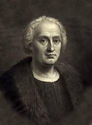 Christopher Columbus (1451-1506) Christopher Columbus, who tried to learn characteristics of currents started from western coasts of the Atlantic Ocean, had determined that currents couldn’t move on the straight line. The mentioned river turns to the left and to the right. When the Genoese seaman entered the current’s embrace, he decided to sail towards the west. But Ferdinand van Olmen sailed to the western part of the ocean by means of Canary and North Passat currents and left those coasts by means of the Gulfstream. He had to wander away from that route when vessels sailed towards the north. Pereira also could meet with such tragedy. But it was winter when he fulfilled the king’s task. I’ll explain this problem in the next part according to the chronology. Best regards, the member of Azerbaijan Geographic Society, President grant holder on literature, laureate of the “Golden pen” award, writer/ investigator Ramiz Daniz email: [email protected], [email protected] 1 Дж. Бейкер. История географических открытий и исследований. Перевод с англ. под редакцией и с предисловием Магидовича И. П. Москва, «Издательство иностранной литературы». 1950. стр. 44.
1 И. П. Магидович, В. И. Магидович. Очерки по истории географических открытий, II том. Москва, “Просвещение”. 1982. стр.55
 23434 23434 |
|


 AZ
AZ EN
EN RU
RU


