


 AZ
AZ EN
EN RU
RU
POPE VI ALEXANDR BORGIA DIVIDES THE WORLD INTO TWO PARTS (the begining of article: “Discovery of the New World had ended hegemony of Portugal”)
As it is known, the bull “Inter caetera” signed by the Pope Alexander VI less than two months after the discovery of the New World coasts – on May 4, 1493 at the urgent request of Spanish monarchs surprised Portuguese. According to this document, all territories located at 100 liq west of Azores became property of Spaniards at the result of Columbus’s travel. Agreeing with such division minimized activity of Portuguese in the Atlantic Ocean. Following question occurred: if there isn’t any large territory having strategic importance and significant geographical location in the west of the mentioned demarcation line and below 280 east latitude, what is the significance of the endless ocean? Then people thought that, there wasn’t any land area in the west of Azores, Madeira Islands and Green Cape Islands. 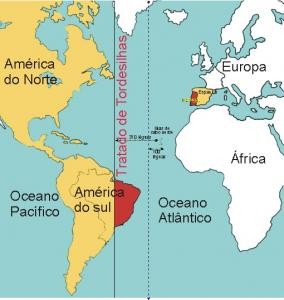 The demarcation line according to Tordesillas treaty Expeditions of Vogado and Ferdinand van Olmen couldn’t achieve any success in mentioned parts of the ocean. Spaniards had achieved their goal in accordance with the bull of Alexander VI on May 4. Now it was Portuguese’s turn. If Christopher Columbus could leave Canaries and discover large land area in the west, Portuguese could do it too. As seafaring and navigation had developed highly in Portugal, Portuguese also could leave one of islands located near the Pyrenean peninsula and discover unknown lands in the west. Southern part of Africa had already been conquered and way out to the Indian Ocean had been opened. One question worried everybody: what was the distance between those lands and the Old World and at which latitudes were they situated? King Juan II knew very well that, Columbus’s travel had lasted for seven months. But it was unknown, how many days he had sailed in the ocean. In spite of it, the king didn’t want to waste time in vain. Secret expedition began to be prepared by Portuguese. Thus, real discovery of Brazil may be made clear. The expedition had to be started in 1493. Probably, preparation works were realized out of the Pyrenean peninsula and in Madeira Islands. As hot days had passed and stormy weathers were characteristic for autumn of those latitudes, this work had to be carried out on the north-western coast of Africa. They had to use other islands in order to prevent risks. From this standpoint, the most convenient geographical location was the location of Green Cape Islands and remote western point of Africa located near the gulf of Guinea. Portugal, which didn’t want to declare its regard for the mentioned division, began to declare dissatisfaction after a year and demanded the Pope to move the demarcation line for 270 liq towards the west. Representatives of both kingdoms met with the participation of Alexander VI in Tordesillas in 1494 and the demarcation line was moved for 370 liq away from Azores (for 2200 km towards the west from those islands) according to the next treaty concluded on June 7. According to the treaty of Tordesillas, all terri-tories located in the east of the demarcation line belonged to Portugal, but lands located in the west belonged to Spain. In a word, Spain was considered owner of America except Brazil and Portugal was considered owner of Africa and India according to the Pope’s bull.1 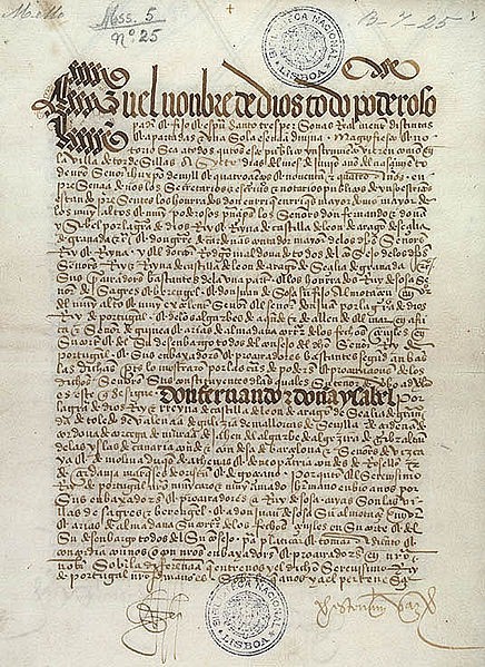 The bull of the Pope Alexander VI signed in Tordesillas (1494)
Portuguese were lucky as Columbus was on coasts of the New World when they held negotiations with Spaniards in Tordesillas and they could realize their purposes. If the Genoese seaman was in Spain, he wouldn’t allow to move the demarcation line for 270 liq towards the west as he knew that, there was a land area on the west of the prime meridian found by Tusi (the line located at 340 towards the west from today’s Greenwich meridian) and Portuguese wanted to appropriate that territory by moving the demarcation line for 270 liq towards the west. It was too late when Christopher Columbus returned from his travel – Portuguese could deceive Spaniards and signed Tordesillas treaty. Authority of Spain increased in Europe as soon as the Reconquista ended in that kingdom (1492). Arabian emirates of the Pyrenean Peninsula began to disappear from the political map since the beginning of VIII century. The Pope Alexander VI, who took into consideration all these facts, began to treat Spanish kings respectfully. Historians think that, the mentioned pontificator had played exceptional role in appropriation of the continent located in the western part of the Atlantic Ocean by Spain. Because he had declared Spain owner of those territories in his bull “Inter caetera” signed on May 3, 1493 after Columbus completed his first travel. Besides it, Alexander VI entrusted Castilia and Aragon with management of the church in the Pyrenean Peninsula and newly discovered lands. In March, as soon as Christopher Columbus returned from his first travel, Spanish monarchs asked the ambassador Bernardino de Karvahala (relative of Hernan Cortes and bishop of Badajoz), who was in Rome, to activate his activity there. The ambassador did his best and made the Pope to sign well-known bull “Inter caetera” in two months. Adoption of that bull demanded great responsibility from Alexander VI as he didn’t want to interfere in works of his ancestors and to trample on rights of catholic kings. Because Spaniards had discovered unknown lands on the other side of the Atlantic Ocean and they had to convert population of those territories to Christianity in accordance with well-known bull. 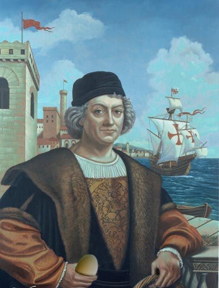 Christopher Columbus (1451-1506) It was noted in the document that, islands and large land area located in the west towards India, in the place where vessels didn’t pass should be given to Spanish kings. The pontificator, who didn’t want to irritate Portuguese, mentioned that, Portuguese would have authorities in Africa, Guinea and Gold Coast (the coast line located in the north of the gulf of Guinea) and Spaniards would have same authorities in lands located on the other side of the ocean. The Portugal king Juan II didn’t want to declare his dissatisfaction at first, but after several months he began to defend de facto rights concerning those lands taking into consideration the treaty signed in 1481. After it, the Pope was obliged to look through his decision again, invited parties to negotiations after a year, on May 4 and made concessions to Portuguese. A month after that date, on June 7, Alexander VI made some changes on the treaty signed a year ago in Tordesillas, made some concessions and ratified that document. The treaty of Tordesillas may be considered a victory of Portuguese as the demarcation line was moved for 100 liq towards the west from Azores in accordance with Spaniards’ offer in 1493 and for 370 liq towards the west from Azores in accordance with Portuguese’s insistence. Special commission of Portuguese and Spaniards had to determine location of the demarcation line before the end of 1495 in accordance with the treaty of Tordesillas. But this task couldn’t be fulfilled because of the discontent between Spaniards and Portuguese cosmographers (The conflict occurred between two kingdoms in 1512 for lands located in South America as it was expected).1 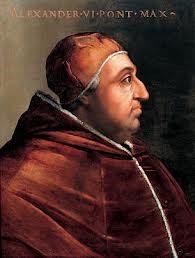 The Pope Alexander VI (Borja or Borgia) All territories located in the left of 380 west longitude were given to the jurisdiction of Spanish monarchs according to the treaty concluded on May 4, 1493. Portuguese began to think about adequate steps as soon as heard it. Portuguese diplomatists made urgent steps before the treaty of Tordesillas. They understood that, the territory located on the other side of the ocean will be lost and that’s why tried to organize direct negotiations with Spaniards. Christopher Columbus began his second travel towards coasts of the New World with 17 vessels and 1500 persons on September 25, 1493, when the representative of Portuguese was on his way to Tordesillas. Before this event, in July Alexander Borgia published the third copy of his bull signed on May 3 with the name “Eximiae devotionis”. This document offered compromise for both parties. 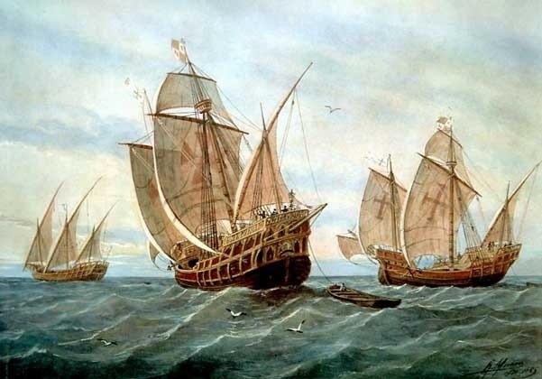 Christopher Columbus’s expedition passes the Atlantic Ocean
Before parties solved the problem without interference of the Pope, Alexander VI issued his fourth bull in December, 1493 with the name “Dudum siquidem” and showed its date as September 25. After that document was issued, Portuguese protested against the Pope as all territories between the demarcation line and eastern part of India had become property of Spain. Nevertheless, India was the territory of Portugal in accordance with the treaty of Alcasovas and Spaniards had agreed with that document. Portuguese noted that, the present treaty was against their interests. They hadn’t any way for sailing to India as Bartolommeo Dias (1488) had discovered remote western point of Africa before the travel of Christopher Columbus and had found way out to the Indian Ocean. The fourth bull of the Pope Alexander VI issued in December of 1493 brought Portuguese to bay and they decided to make urgent steps. They decided to send expedition to coasts of South America. Then Portuguese knew that, Columbus had travelled to lands he had discovered for the second time. Best regards, the member of Azerbaijan Geographic Society, President grant holder on literature, laureate of the “Golden pen” award, writer/ investigator Ramiz Daniz email: [email protected], [email protected] 1 История средних веков. Абрамсон М. Л., Кириллова А. А., Колесницкий Н. Ф. и другие. Под редакцией Колесницкого Н. Ф. – 2-е изд. исп. и доп. – М., «Просвещение», 1986. стр.393.
1 Португальская колониальная империя, СИЭ, т. 11, с. 451-452.
 35059 35059 |
|


 |
 |